


•Andersen- Russian-Georgian War
♣ August 2008
♥ სამაჩაბლო – Samachablo

RUSSIAN-GEORGIAN WAR
AND THE CONFLICT IN GEORGIA’S PROVINCE OF “SOUTH OSSETIA”
WHAT IS THE SO-CALLED “SOUTH OSSETIA”?
By Andrew Andersen
South Ossetia also known in Georgia as Shida Kartli and Samchoblo, is an inalienable part of Georgia that was granted administrative autonomy after the Soviet conquest of Georgia in 1921. As of today, there are several myths developed by Russian imperial propaganda and occasionally repeated by various media due to the fact that there is a limited number of people both in the west and in the east who had a chance to learn the detailed history of the region.
Myth Nr. 1: There was once a united Ossetia partitioned by the Bolsheviks after 1917between Russian Federation and Georgia.
That statement is simply not true. There was, in fact, no “South Ossetia” at all until the second half the 19th century when it appeared as a pure ethnographical but in no way political term. Even if one looks at the geographical map of the area one will notice that “the two Ossetias” are isolated from one another by the Main Caucasus mountain range, the natural border between Russia and Georgia. Until the construction of the strategically important Roki tunnel in 1985, the Main Caucasus range had only two narrow passes between the “two Ossetias” completely blocked by snow and thus impassable during most of the year, except the summer months.
If you take a detailed look into the regional history you will find out that modern South Ossetia never ever existed as a separate political entity but always was a part of eastern Georgian provinces or eastern Georgian states even during the periods of fragmentation. After the incorporation of Georgian states into the Russian Empire in the first half of the 19th century, the territory of modern South Ossetia existed in the form of several districts and cantons of the Tiflis province (former East Georgian Kingdom) and a canton of the Kutais province (former Kingdom of Imereti).
It is difficult to say for sure when exactly did the Ossetians settle in Georgia, but there is some evidence that it did not happen until the 19th century. According to Russian historian Nikolai Dubrovin (1837-1894) “… it was the shortage of arable land that was the reason for the resettlement of some Ossetians across the Main Caucasus Range and voluntarily accepted the bondage imposed on them by georgian landlords. After having settled the gorges of Big Liakhvi, Small Liakhvi, rekhula and Ksani rivers, they became the serfs of the princely families of Eristavi and Machabellli. Those settlers are now called ‘the south Ossetians’ further subdivided into various tribal groups named after the gorges they reside. Those groups include the Ksanians, Liakhvians, Gudushaurians, Magran-Dvaletians, Jamurians, etc. Many Ossetians also settled in Khevi and Mtiuli gorges”[i]
An indirect proof of the hypotesis od Dubrovin is the fact that the majority of South Ossetians used and still use to have Russian or russified last names while the last names of the majority of traditional inhabitants of Georgia no matter what their ethnic backgrounds was, were either Georgian or Georgianized.
Myth Nr. 2: It was Joseph Stalin who granted South Ossetia to Georgia.
That is as far away from the truth as the previous myth. Independed Georgia re-created in 1918, included the territory of modern South Ossetia and afther the Soviet conquest of 1921was incorporaed into the USSR having South Ossetia as an autonomous province.
Let us add to the above that there is no single map or atlas published in Russia, the USSR or in the west until 2008 that would show any “united Ossetia” or South Ossetia not being a part of Georgia.
Pre-history of the conflict
Coming soon
ETHNIC MAKEUP OF THE AREA
By Andrew Andersen and George Partskhaladze
At least since the 11th century, Georgia saw some Ossetian immigration (most of them coming as mercenaries). However, mass migration of the Ossetian peasants into the Georgian lands across the Caucasus range did not occur earlier than the middle of the 18th century, predominantly into Georgian provinces of Shida Kartli (at that time, the Kingdom of Kartli) and Racha (Kingdom of Imereti). Depopulated by a series of wars that ravaged through Georgia throughout the 17th and 18th centuries, the territory of Upper Kartli a part of which was in the early 20s of the 20th century converted into South Ossetian Autonomous Province, was re-settled not only by the Georgians but also by representatives of other ethnic groups that included but were not limited to the Armenian and Greek refugees coming from the Ottoman Empire and Ossetians coming from the north across the Greater Caucasus range.
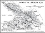
The below excerpt from the ethnic map of the South Caucasus by Andrew Andersen and George Partskhaladze based on Russian imperial statistics of the late nineteenth century depicts rather complicated ethnic palette of the future “South Ossetia” where Georgian settlements are lemon-colored and Ossetian settlements are dark red. Pink color goes for Armenians, golden for Greeks, light brown for Russians, light blue for Germans and orange for Vainakhs.

According to the map, Ossetian settlements were scattered all over the Upper Kartli forming majority predominantly in underinhabited highlands of the north along the Georgian Military road. Please note that according to Russian statistics of the described period there was no single Ossetian inhabitant in the village of Tskhinval (Tskhinvali) inhabited by Georgians and Jews.
By the beginning of the 20th century, most of the Ossetians of the South Caucasus lived in a bunch of enclaves scattered across the borderlands of the Counties of Dushet, Tskhinval, Shorapani and Racha (mainly in the rural counties of Tskhinval, Ksani, Sachkhere and Oni) as well as in the historical Georgian province of Trialeti at the described period included into the County of Gori (sector of Khidistavi and part of the sector of Borjomi). Smaller amount of Ossetians (several hundred people) also resided in the Territory of Kars. Unlike many other ethnic enclaves of the South Caucasus, Ossetian settlements did not tend to be monoethnic, and most of the Ossetian villages had Georgian and other ethnic elements in them.
The below tables clearly illustrate the amount of Ossetians in the Russian Caucasus as well as the ethnic makeup of the core Georgian provinces of Tiflis and Kutais

CHRONOLOGY OF THE CONFLICT, 1989-2008 Coming soon
CHRONOLOGY OF THE RUSSIAN-GEORGIAN WAR / AUGUST, 2008 Coming soon
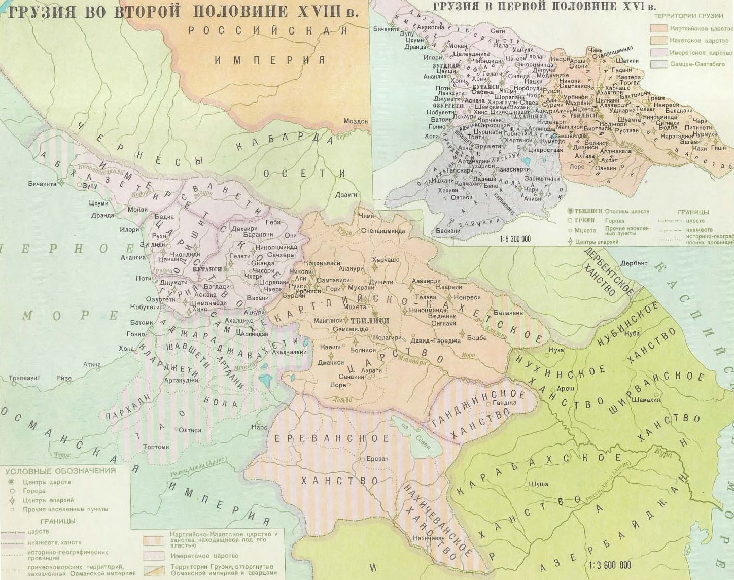
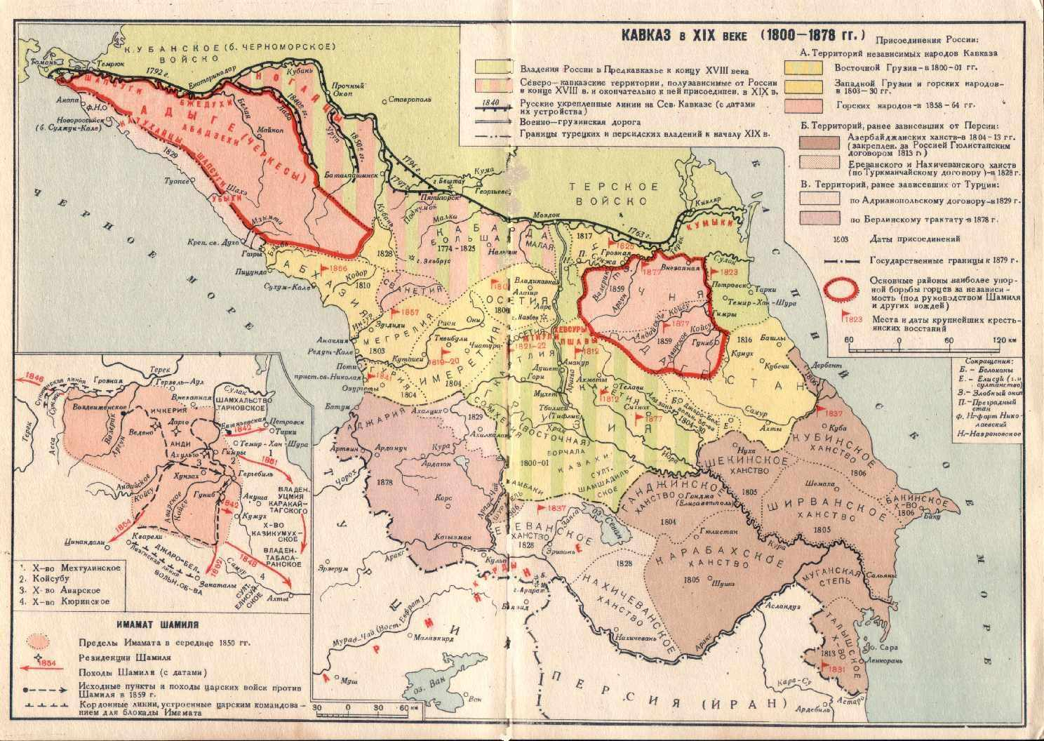
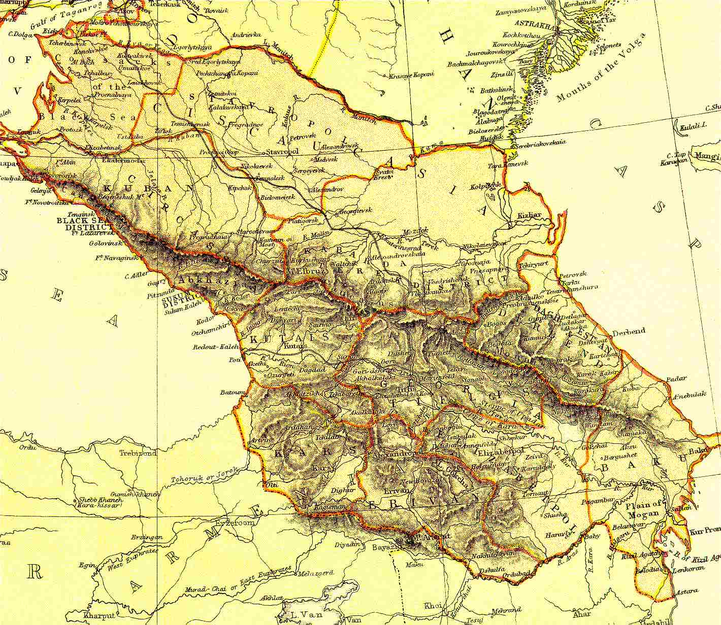
MAPS, HISTORY AND CORPORATE INTERESTS
Andrew Andersen
The below maps clearly show that all modern propaganda regarding one “United Ossetia” so far unknown to historians but according to some Russian authors – incorporated into Russia in 1774 – is nothing but pure insinuation aimed exclusively at fuelling irrational and counter-productive conflict between Ossetians and Russians. I am deeply apologetic for the fact that the below maps are in Russian but, alas, British, American and other Western historians hoped and sincerely believed that the region in question would never leave the Russian realm and spared efforts and funds on the research. I made some of the historical maps of the Caucasus but not all the required ones. But in any case, I would like to show you not my maps (who knows whether I was objective while making them?) but maps printed in the USSR and pre-communist Russia.


Realisez un voyage memorable en croisiere said
Blop, Je suis agée de 35 ans .
Mon nom est Calandre.
Mon travail est viticultrice ! Mon naturel est plutôt
réservé.
LikeLike